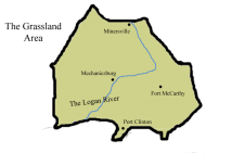
The Desert Area
Revision as of 19:30, 26 March 2019 by Maximumjedi (talk | contribs) (Created page with "{{Infobox country |color=yellow |text_color=white |name=The Desert Area |flag=Flag_of_the_Grassland_Area.png |arms=Coat_of_Arms_of_the_Grassland_Area.png |motto="Rowt Ngenuit"...")
| The Desert Area | |||||
|---|---|---|---|---|---|
| |||||
| Motto: "Rowt Ngenuit" (Growth and Ingenuity) | |||||
| Anthem: | |||||
| Geography | |||||

| |||||
| Area | 3,938,997km2 | ||||
| Highest point | Mount Kindikil, 4.7 Miles | ||||
| Longest river | The Logan River | ||||
| Demographics | |||||
| Population | 126 Million | ||||
| • Growth | 4.9%/year | ||||
| Median age | 32.9 years | ||||
| Demonym | Desertinian | ||||
| History | |||||
| Before Statehood: | The Territory of the Desert | ||||
| Confirmed as 3rd Quentinian State: | January 2nd, 1834 | ||||
| Government | |||||
| Capital | Baltimore | ||||
| Official language | Farmine | ||||
| Type | Mild Republican State | ||||
| Legislature | The Desert Area House of Legislation | ||||
| Governor: | Theodore Rothman | ||||
| Head Legislator: | Grace Meinke | ||||
| Secretary of General Welfare: | Melanie DeSevus | ||||
| State Decider: | Tyler Annison | ||||
| Districts: | Lower Plains District, The Yebenna District, The Descekin District, Desert Northern Coastal District, Southwestern Hills District, The Migood District, and The Liberation District | ||||
| Economy | |||||
| Currency | The DIG System (Ð) (DIG) | ||||
| GDP | Ð | ||||
| • Per capita | Ð5,721 (57,214) | ||||
| • Growth | 1.6%/year | ||||
| Sectors |
9% Agriculture | ||||
| Unemployment | 5.1% | ||||
| Development | |||||
| Life expectancy | 80.2 years | ||||
| Clean water access | 99% | ||||
| Literacy | 99% | ||||
| Enrollment | 95.6% | ||||
| • Primary | 99.9% | ||||
| • Secondary | 98.3% | ||||
| • Tertiary | 88.8% | ||||
| Standards | |||||
| Measures | DuBuis System | ||||
| Date format | Month-Day-Year | ||||
| Traffic | Right-Hand | ||||
| Codes | |||||
| ISO code | GA | ||||
| Internet TLD | .nwd | ||||
| Time Zones | {{{VST}}} | ||||
| Calling code | +7 | ||||

